|
Historical HighlightsHistorical Markers in the Town of Sand Lake |
[Click on images to enlarge them]Until a few years ago, Sand Lake had but one historical marker in the town. |
|
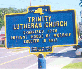
Trinity Lutheran Church
That "lone marker" is the one in front of the former Trinity Lutheran Church (currently West Sand Lake Community Church In 1838, parishioners left the Zion Evangelical Lutheran Church over the issues of antislavery and temperance and formed the Second Evangelical Lutheran Church. This church was a station on the Underground Railroad for fugitive slaves. Rev. Nickolas Van Alstyne, with the secret name "Paul," gave messages in code during Sunday sermons for abolitionists' meetings and the movement of slaves to freedom. Zion's Lutheran then became the First Evangelical Lutheran Church. In 1926, the congregations of the First and Second Evangelical Lutheran churches reunited and became Trinity Lutheran Church. Services were held in the original 1816 Zion Evangelical, or First Evangelical Lutheran Church. The building was struck by lightning and burned on August 14, 1944. Between 1944 and 1954, services were held in the Second Evangelical Lutheran Church building while the present brick building was being completed. The site of the Second Lutheran Church is the present Sand Lake Dry Cleaning and Laundromat. (Location: West Sand Lake, Rt. 150.) |
|
In the late 1990s, Town Historian Judy Rowe began an emphasis on getting deserving sites identified with historical markers. |
|
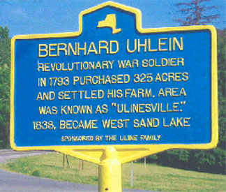
Bernhard Uhlein
The first marker of this initiative was donated by the Uline Family Association in memory of Bernhard Uhlein, who served in the Revolutionary War. He was a Palatine German who arrived in Philadelphia as an indentured worker. He made his way to Rensselaerwyck's East Manor and received a 325-acre grant of land from the Patroon VanRensselaer. His farm became known as Ulinesville and in 1838 it was named West Sand Lake. (Location: West Sand Lake, Rt.150 South at Shaver Road.) |
|
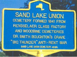
Sand Lake Union
The Sand Lake Union Cemetery Association purchased a sign to mark the formation of the Cemetery in 1841 from the Rensselaer Glass Factory and Woodbine cemeteries. The earliest marked gravestone is 1807. In addition to many Revolutionary and Civil War gravesites, James Averill's horse Moscow is buried on the Averill plot. The Averill family had Moscow's grave marked a few years ago. Also there is the grave of Dr. Smith Boughton, known as "Big Thunder" during the Anti-Rent War period. Boughton's grave is directly opposite that of Willard Griggs, to this day the only Rensselaer County Sheriff's Deputy to die in the line of duty. (Location: Sand Lake, Routes 43 and 66.) See also Amazing Graves for more information about Sand Lake Union Cemetery. |
|
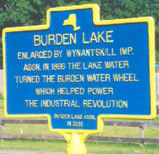
Burden Lake
The Burden
Lake Association The original marker disappeared in 2005 but was replaced in summer 2007. Sometime in 2020, the original resurfaced, and the Association offered it to Kay’s Pizza, at whose parking lot it now resides! (The replacement remains as noted above.) |
|
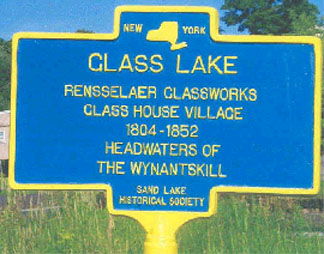
Glass Lake
Jeremiah Van Rensselaer founded the Rensselaer Glass Factory in 1804. The village on this site consisted of 34 workers' homes, a store, pottery, ashery, school, doctor's office, wood cutters' cabins, a home for the factory superintendent, a home for the superintendent in charge of glass making, horse barns, warehouses, cylinder packing house and boarding houses. The land consisted of a wood lease from Patroon Van Rensselaer of 5000 acres and 346 acres around the lake. Glass Lake is also the headwaters of the Wynantskill Creek and makes its journey as described for the Burden Lake marker above. (Location: Glass Lake, Routes 43 and 66 at Glass Lake Rd.) |
|
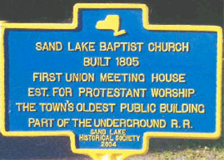
Sand Lake Baptist ChurchSand Lake Baptist Church The building
was erected initially as a meetinghouse for Baptists, Methodists and Presbyterians. The
Methodists sold their meetinghouse rights to the Presbyterians in 1831 and built their church at Glass Lake. In
1835, the Presbyterians sold their portion of the church to the Baptists and erected a church at the corner of
Routes 43 and 66 in Sand Lake (now the Sand Lake Center for the Arts). On December 29, 1831, 18 believers were
set apart to form an independent Baptist Church to be known as the "Second Baptist Church of Sand Lake."
(After the town of Poestenkill was formed from part of the town of Sand Lake in 1848, the First Baptist Church
changed its name to Poestenkill Baptist Church and the Second Baptist Church was called Sand Lake Baptist Church |
|
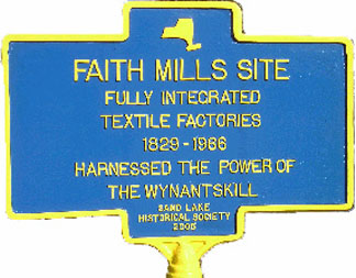
Faith Mills Faith Mills Site From the early 1800s up to 1966, any number of factories that produced knit cotton and woolen goods, warp yarn
and paper dotted the landscape along the present Burden Lake Road. One of the most notable and enduring was Faith
Mills, which finally ceased operations in 1966. (Location: Averill Park, on Burden Lake Road off Route 43.)
See reminiscences of those connected with the Faith Mills complex. See also arts letters & number |
|
Log Church Site, 1776Lutheran Church Log Building The marker now designates the site of the first church building in the town, a log building serving as pastor’s home, schoolhouse and Lutheran church located on the present Thomas I. Cipperley property. Several stones from the cemetery are preserved at Eastfield Village. The church was the forerunner of the Zion’s Evangelical Lutheran Church |
|
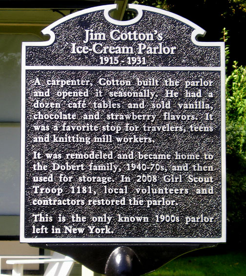
Cotton HouseJim Cotton's Ice-Cream Parlor A carpenter, Cotton built the parlor It was remodeled and became home to This is the only known 1900s parlor More about the Cotton House. |
|
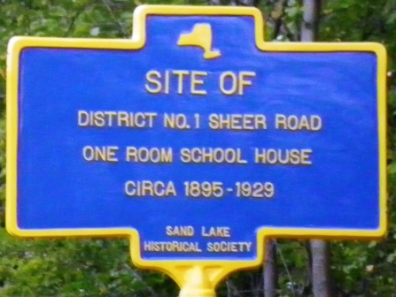
District 1 School HouseSite of (Located on the west side of Burden Lake, on Sheer Road, north of Biittig Road.) More about the this and other Schools Prior to 1929 | Read about the dedication of this marker! |
|
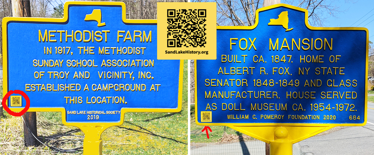
Methodist FarmIn 1917, the Methodist This historical marker was dedicated on July 6, 2019, at the entrance to Methodist Farm, on the southern end of Crooked Lake. (The marker is located at the entrance to the Farm on Methodist Farm Road, off Routes 43 and 66.) More about Methodist Farm | Read about the dedication of this marker! |
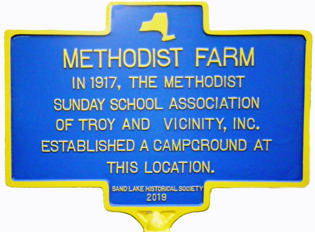 Marker by the Sand Lake Historical Society, 2019 |
Fox MansionBuilt ca. 1847. Home of This marker was unveiled and dedicated on October 3, 2021! The marker is made possible by a grant from the William G. Pomeroy Foundation. More about the Fox Mansion | Read about the dedication of this marker! |
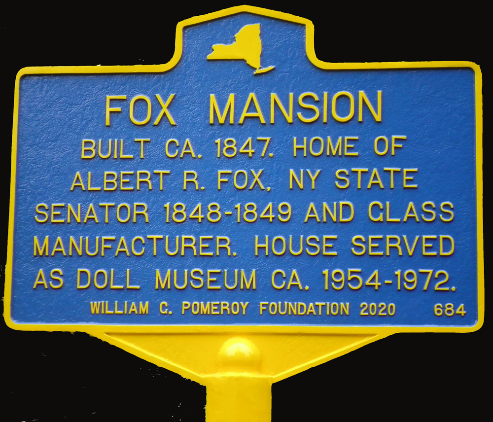 Marker via grant from the William G. Pomeroy Foundation, 2021. |
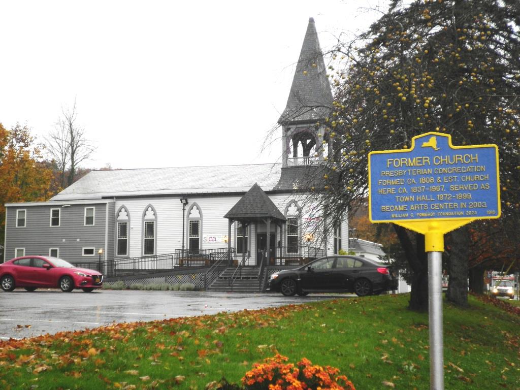
Former ChurchPresbyterian Congregation
|
Marker via grant from the William G. Pomeroy Foundation, 2023. |
Hazel DrewGhost of a young woman said This marker was unveiled and dedicated on October 6, 2024. The marker is made possible by a grant from the William G. Pomeroy Foundation in conjunction with New York Folklore. More about Hazel Drew in Historical Highlights, volume 43, no .3, Spring 2017 (PDF format)! |
 Marker via grant from the New York Folklore / William G. Pomeroy Foundation, 2024. Photo by John Losee |
Town GarageERECTED AS A CLIFFORD C. HASTINGS, SUPERVISOR Not quite a roadside historical marker; rather, a commemorative plaque noting some of the unique history of the former Town Garage on Eastern Union Turnpike at Holcomb Road. |
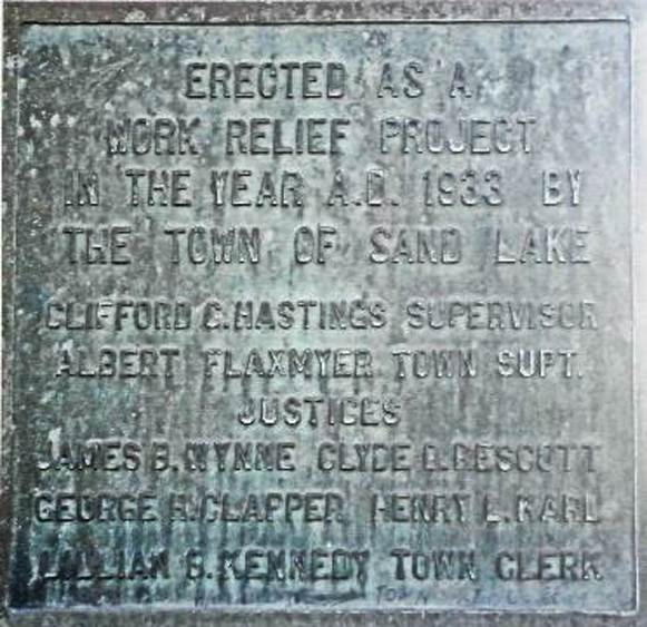 Plaque erected on the northeast corner of the [former] Town Garage in 1933. |
Information taken from Historical Highlights 31-1, Fall 2004; 41-2, Winter 2015; 46-1, Summer 2019; 48-2, Fall 2021; and additional sources. |
|
QR Codes
|
|
Check out our interactive map showing locations of Sand Lake's roadside historical markers! |
|
More about historical markers locally and beyond... (links below open in a new window
|
|
 |
|
Have any suggestions for historical markers in Sand Lake? If so, please contact us! |
 August 10, 2007; revised
October 22, 2024
-- asm. © 2002-2024 Sand Lake Historical Society; all rights reserved.
August 10, 2007; revised
October 22, 2024
-- asm. © 2002-2024 Sand Lake Historical Society; all rights reserved.