The story of the building of the Burden Lakes is an interesting
part of the history of Sand Lake. It is hard to imagine today, when driving along the shores of Burden Lake, that
the lake was once a green valley with a small stream in its center. At the south of this valley, in Nassau, was
Martins Lake, a relatively small lake.
It all began in the year 1829. The Wynantskill Association, an association of mill owners with mills along the
Wynants Kill, had just been organized. Their purpose was to gain control of the lakes that feed into the Wynants
Kill and regulate its flow. By damming up these lakes, raising the water level and installing gates, the flow could
be regulated to increase its usefulness of the stream for milling purposes.
When the occupants of the farms that bordered Martins Lake were approached by the Wynantskill Association, they
refused to have their lands overflowed. Instead, these farmers agreed to allow the Wynants Kill Association to
build a dam and control gates at the lake's outlet and then dig a ditch so that the lake could be drawn down to
supply extra water as required by the Association.
To mark the existing high water level and eliminate any future dispute about the level, a hole was drilled in
a large rock on the north shore at Bristol's farm. The farmers, in consideration of $1 each paid by the Wynantskill
Association, signed an indenture giving permission to build the dam and draw down the lake. Members of the Association
were assessed $20 a share to cover the cost of the work. The dam was completed in 1831. This arrangement remained
in effect until the 1860s.
The Association was always hopeful that they could increase the size of Martins Lake by building a large reservoir,
creating a dependable supply of water to power the mills. The idea was to build a dam downstream on the outlet
stream of Martins Lake and flood the entire valley. This effort was frustrated over the years for two reasons:
first, the reluctance of the land owners whose farms would be flooded to give their permission; and second, the
quarter sale stipulation in the original Stephen Van Rensselaer's leases. These stipulations discouraged the sale
of the land. Finally, in the early 1860s these problems were resolved, and planning began.
 The Wynantskill Improvement Association, a reorganization of the Wynantskill Association, engaged the services
of Burton Thomas, a self-made civil engineer living in West Sand Lake, to design the project. Thomas saw two problems.
First, the water level of this new reservoir had to be determined in order to estimate the total area that would
be flooded and the quantity of water that could be stored. Second, it had to be determined whether the proposed
watershed would be ample to fill the new lake. The Wynantskill Improvement Association, a reorganization of the Wynantskill Association, engaged the services
of Burton Thomas, a self-made civil engineer living in West Sand Lake, to design the project. Thomas saw two problems.
First, the water level of this new reservoir had to be determined in order to estimate the total area that would
be flooded and the quantity of water that could be stored. Second, it had to be determined whether the proposed
watershed would be ample to fill the new lake.
The study of the watershed concluded that it would be necessary to find an additional supply of water to fill this
new lake. To resolve this problem, it was decided that it would be necessary to build a dam on the Wynantskill
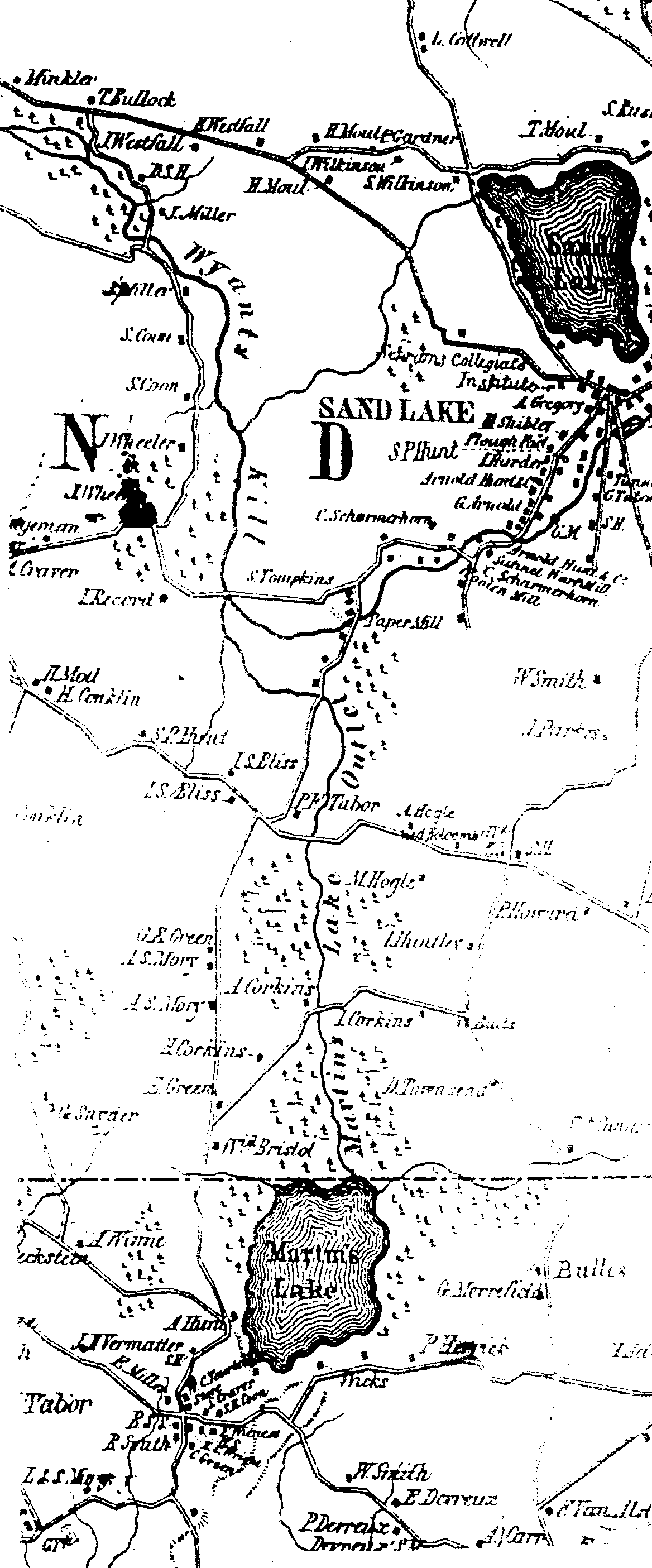
Creek and divert its waters through a dike into the then-dry valley. The chosen location of this dam was just below
the Tompkins Paper Mill.
Before work could be started, an agreement was made with Staats D. Tompkins. So that the dam would not interfere
with the paper mill operation, the water level resulting from the proposed dam should be two feet below the mill
tailrace. In addition, the Association would at all times protect the water rights of the mills upstream of the
diverting dam. To accomplish this it was agreed that, once the new reservoir was completed, the Wynantskill Improvement
Association would draw water from Sand Lake (Crystal Lake), Glass Lake and Crooked Lake in sufficient quantity
to operate The Arnold Cotton Mill at full capacity.
 At the same time the above conditions were made with Tompkins, the Association was negotiating with the farmers
located along the creek from Martins Lake for permission to flood their lands. To determine the new water level,
a survey line was then run from the Paper Mill tailrace level to the hole that was drilled at Martins Lake in 1831.
It was calculated that the new lake would be raised eight feet above the old level. To mark this new high water
level, a second hole was drilled in a rock at the north end of the proposed lake and an iron bolt inserted. With
these issues resolved and design completed, work was begun. At the same time the above conditions were made with Tompkins, the Association was negotiating with the farmers
located along the creek from Martins Lake for permission to flood their lands. To determine the new water level,
a survey line was then run from the Paper Mill tailrace level to the hole that was drilled at Martins Lake in 1831.
It was calculated that the new lake would be raised eight feet above the old level. To mark this new high water
level, a second hole was drilled in a rock at the north end of the proposed lake and an iron bolt inserted. With
these issues resolved and design completed, work was begun.
Just when construction began and how long it took to complete the work is not fully known. It is estimated that
work began in the spring of 1863. It was a major project. Work consisted of four parts: many man hours of labor
digging ditches; hauling earth and stone in horse-drawn carts; and building dams, dikes and roads.
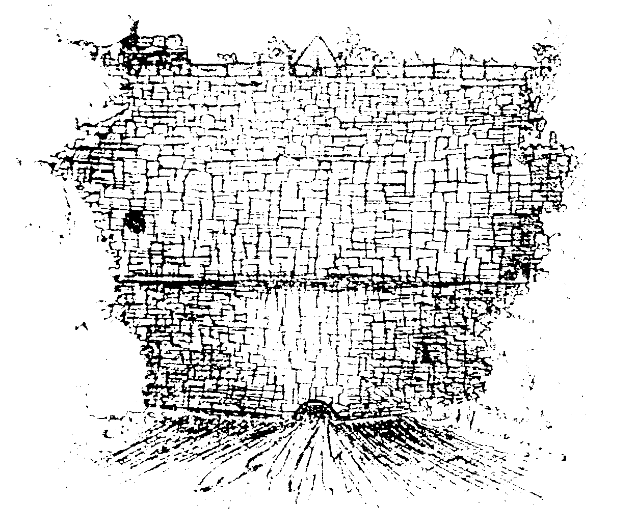
One part of the project consisted of building a large dam across the stream coming from Martins Lake. An earthen
dam about 20 feet high and wide enough to carry a road — today's Burden Lake Road — was constructed. One of the
features was the stone face, constructed of local cut stone without the use of mortar or cement. At the base of
the dam, a trunk or pipe complete with a gate valve was installed to regulate the water flow from the lake. This
flow of water would follow the original stream bed from Martins Lake. Today, it is hard to see the beautiful stone
work without walking through a wet and tangled area.
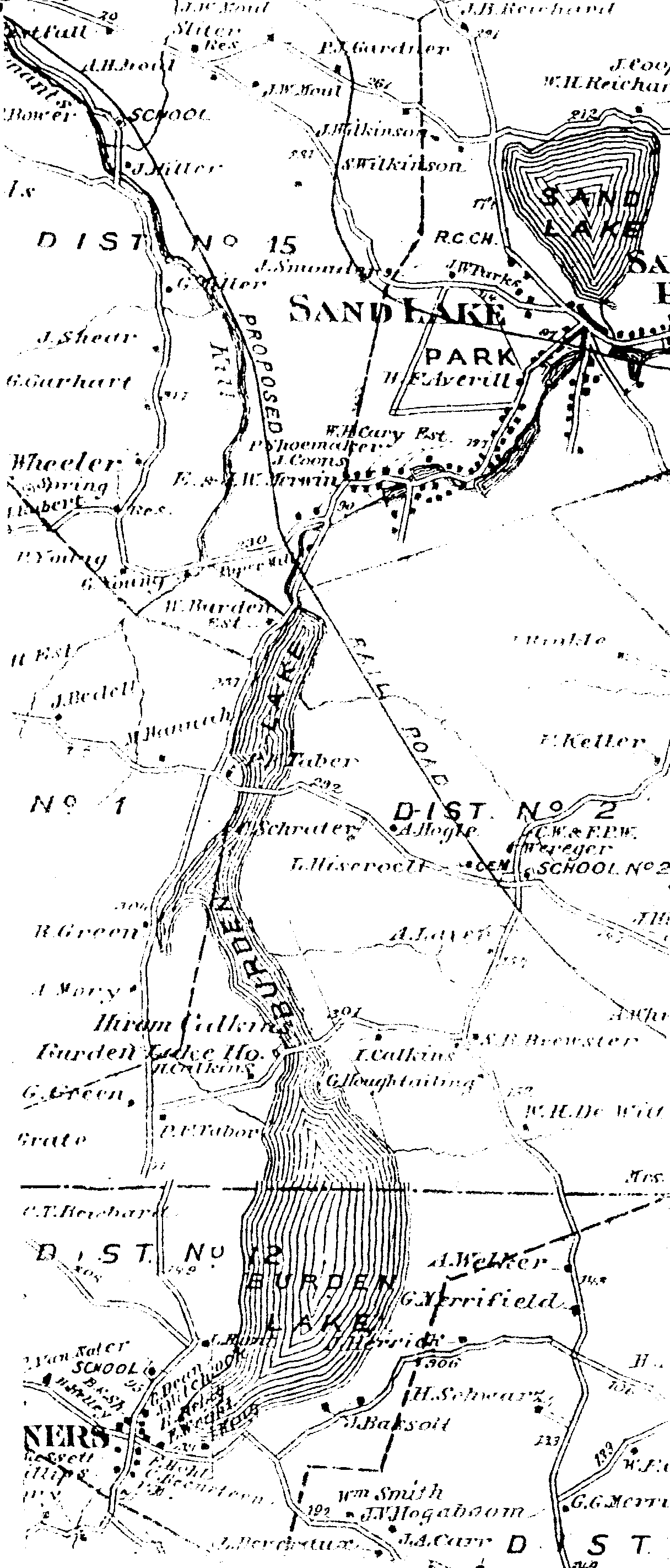
Between the Burden Lake dam and the Wynants Kill, a ditch and dike were constructed. This dike, about 900 feet
long, was to convey the waters of the Wynants Kill into the new lake. The dike can be seen today when driving along
the Burden Lake Road. Next, a dam was built across the Wynants Kill to divert the water from the Wynants Kill,
through the canal formed by the dike and into the lake. The top of the diverting dam was at the same level as the
bolt in the rock designating high water. Thus, in periods of low water in the kill, water would flow into the lake
and not over the dam. In periods of high water, the excess water would overflow the dam, maintaining the water
level.
In addition to the dams and dikes, there were two roads that crossed the valley. Sand and gravel had to be carted
from local sand banks to raise the road bed above high water. At each of these roads — First Dike and Second Dike
Roads — a wooden trunk was installed at the low spot to allow water to flow and the lakes to be drained. In addition,
a spillway and bridge were constructed to connect the lakes.
 With the dams, dikes, canals and roads completed, it was time to fill the reservoir. Just when it was started is
unsure. It seems that the process began in the fall of 1865 and the lakes filled by the spring of 1866. [If any
one has more accurate information, we would like to hear from you.] When completed, the gate valve in the Burden
Lake dam would be used to control the flow to the mills. This usually meant the closing of the valve at day's end
to store water and opening the valve in early morning to supply the mills. With the dams, dikes, canals and roads completed, it was time to fill the reservoir. Just when it was started is
unsure. It seems that the process began in the fall of 1865 and the lakes filled by the spring of 1866. [If any
one has more accurate information, we would like to hear from you.] When completed, the gate valve in the Burden
Lake dam would be used to control the flow to the mills. This usually meant the closing of the valve at day's end
to store water and opening the valve in early morning to supply the mills.
Looking at the dates of the indentures for the flooded lands, it seems that all of the agreements about flooding
the land were made before construction began but not completed until after the lake was flooded and the true extent
of flooding was seen. In the indentures with the landowners, all dated 1866, all have the same description of the
new water level: "The top of the overflow apron shall be on a level with an iron bolt set in a rock on the
north east side of the lake bearing south 85E 15' east 239 3/12 Feet from the center of the stem of the water gate
at the discharge trunk from the lake."
The agreement with Staats Tompkins mentioned above, which gives all the conditions to allow the building of
the dams and dikes, ends with the statement: "And whereas the said dam and its connections, having by the
said Wynantskill Improvement Association, being completed the water of the said Wynants Kill turned and running
into Martins Lake as contemplated, now therefore in consideration of the aforesaid premises. The Wynantskill Improvement
Association hereby agrees to and with S. Tompkins...." It is dated March 5, 1866.
In 1866 the Wynantskill Improvement Association had 12 members. Four mills — Tompkins Paper Factory, Arnolds
Cotton Factory, Knowlson Wool Factory, and James Akin Knitting Mill — were upstream of the diverting dam and did
not benefit from new lakes. However, during this same period the Association was doubling the size of Glass Lake
(but that's another story). The downstream members, all of which contributed to the cost of the project, were:
Kidder and Akin in West Sand Lake; Troy Woolen Company in Albia; The Smart Paper Mills off Campbell's Highway;
H. Burden & Son; Albany Iron Works; Corning & Winslow; and Winslow, Griswold, & Holley — all in Troy.
Henry Burden, the President of H. Burden Company, was also Director of the Wynants Kill Association from its
inception in 1829. He was very active in the organizing and a leading figure of the Association. In recognition
of his efforts, the lake was named in his honor.
Burton Thomas, the engineer, was a man of all trades. As well as being an engineer, he was a landscape architect,
designing many cemeteries; a Postmaster; Justice of the Peace; and Supervisor of the Town of Sand Lake in 1866-67.
Today there are no mills on The Wynants Kill, and the waters of the lakes are no longer regulated. The last
mill, Portec, rolled its last rail joint on October 12, 1989. The Wynantskill Improvement Association, after 170
years of active life, is now looking for ways to close its books.
*NOTE: In 1829, the Wynants Kill Association was formed to shape and control the lakes that discharged into the stream and to draw down and drain the lakes in a way that would be most useful to the mill operators. A trust was set up in 1846.
Chap. 73. AN ACT authorizing trusts for the benefit of the owners and occupants of mill privileges on the Wynants Kill. Passed April 21, 1846. -- The People of the State of New-York represented in Senate and Assembly, do enact as follows: § 1. Trusts of real property may be created for the benefit of persons owning or occupying mill privileges on the creek or stream called the Wynants Kill, in the county of Rensselaer, and the legal title and estate of any property so held in trust shall be vested in the trustees…. § 2. The annual value or income of the property so to be Annually held in trust shall not exceed two thousand dollars… sole objects of the trusts shall be the improvement of said stream, by increasing the head of water and regulating the flow thereof for the supply of the mills and establishments on said stream, by forming reservoirs, connecting lakes and ponds with said streams, and constructing dams and gates at and below the outlets of such reservoirs, lakes and ponds, and by such other works and improvements as will increase the usefulness of said stream for milling purposes…
The law was amended in 1906 to recognize the Wynantskill Improvement Association, a corporation created and organized in 1901 under the membership corporations law.
©1997. Robert J. Lilly, from Historical Highlights, Volume 24, No. 2, Winter 1998 |


 3/25/2000. Revised
8/18/09;
02/22/2020
— asm. © 2002-2024 Sand Lake Historical Society; all rights reserved.